Digital Twin for Urban Planning: Transforming City and Infrastructure

February 6, 2026
Digital Twin for Urban Planning: Transforming City and Infrastructure

Quick Summary: 

As cities face challenges such as rapid urbanization, aging infrastructure, and climate change, traditional planning methods are no longer sufficient. Digital twin technology for urban planning offers a transformative solution by providing real-time, data-driven models that improve decision-making and enhance city management.

Urban areas around the globe are facing unprecedented growth, fueled by rapid urbanization, aging infrastructure, and increasingly complex challenges.

As demands on cities intensify, urban planning has reached a pivotal moment. Traditional planning methods are no longer sufficient to keep pace with the evolving complexities of urban environments.

Enter the digital twin for urban planning, a groundbreaking technology that is transforming how cities are planned, managed, and optimized for the future.

But how can this innovative technology benefit urban planners, architects, government agencies, and other key stakeholders?

This blog will dive into the powerful capabilities of digital twins, showcasing how they are revolutionizing city infrastructure and urban planning. Whether you are an entrepreneur, a government official, or a startup looking to adopt cutting-edge solutions, understanding the value of digital twin technology is crucial to keeping your city’s infrastructure ahead of the curve.

What is a Digital Twin for Urban Planning?

A digital twin for urban planning is a continuously evolving, data-driven virtual replica of a city. This sophisticated model mirrors the city's physical assets, infrastructure systems, environmental conditions, and human activities. Unlike a static 3D digital twin model of working for urban planning, a true digital twin for urban planning and infrastructure integrates:

  • Geometry (2D GIS, 3D city models, BIM)

  • Live and Historical Data (IoT, sensors, APIs, enterprise systems)

  • System Behavior (transport flows, energy networks, water systems)

  • Intelligence (physics-based simulation, AI/ML analytics, optimization)

By continuously integrating these data sources, digital twin software for urban planning provides a living system that not only visualizes the city but also predicts its behavior and evaluates potential outcomes before implementation.

Core Models and System Architecture of Urban Digital Twins

A modern urban digital twin platform is built on a layered, interoperable architecture designed for scalability and longevity.

The architecture includes:

  • Physical City: Buildings, roads, utilities, people, and environmental assets form the foundation of the digital twin.

  • Data Ingestion Layer: Integrates heterogeneous data from various sources, such as GIS datasets, BIM models, LiDAR scans, IoT sensors, and traffic feeds.

  • Modeling Paradigms

    • 2D GIS Models: Used for zoning, land use, and spatial policy analysis.

    • 3D City and BIM Models: Essential for design coordination and construction planning.

    • Graph and Network Models: Used for energy grids, transport networks, and interdependencies.

    • Analytics and Intelligence Layers: Apply AI/ML predictions, optimization, and physics-based simulations for decision-making.

    • Visualization and Interaction Layers: Provide insights through dashboards, 3D environments, and scenario interfaces.

This digital twin for urban planning and infrastructure enables a dynamic, continuously operating city platform that optimizes both planning and day-to-day operations.

A Lifecycle View: From Planning to Operations

Urban digital twin applications evolve alongside the city, ensuring seamless integration from planning through operations.

Here’s how:

Lifecycle View of Digital Twin for Urban Planning

1. Planning and Design Phase

During this phase, the digital twin for urban planning acts as a simulation environment to evaluate land use, zoning policies, and infrastructure capacity. Digital twin cities enable cities to test energy systems for net-zero performance, ensuring energy efficiency before construction begins.

2. Construction and Commissioning Phase

Once projects move into construction, digital twin solutions support coordination, safety planning, and material optimization by aligning design intent with real-world constraints.

3. Operational Phase

As assets become operational, digital twin projects for urban planning transition into real-time monitoring and optimization systems that continuously update the model with live data. This allows for anomaly detection, predictive maintenance, traffic optimization, energy load balancing, and emergency response.

This continuous lifecycle view eliminates traditional disconnects between urban planners, engineers, and operators, ensuring a unified, real-time city management system.

High-Impact Urban Use Cases for Digital Twins

Digital twins for urban planning and infrastructure provide value across a range of high-impact domains:

  • City Planning and Policy Testing: Scenario modeling allows planners to test zoning changes, transport strategies, and development proposals. Optimized mobility design reduces congestion by up to 30%.

  • Infrastructure Health and Predictive Maintenance: Real-time structural health monitoring helps detect micro-failures in critical infrastructure (e.g., bridges and tunnels) days in advance, reducing downtime by up to 40%.

  • Energy and Sustainability Optimization: City-scale physics-based simulations forecast energy consumption, supporting net-zero mandates and delivering 15-25% reductions in energy use.

  • Climate Resilience and Environmental Risk: Models for flood, heat islands, and sea-level rise enable cities to prepare for climate risks and provide real-time alerts during extreme weather events.

  • Traffic and Mobility Management: Live optimization of transport networks improves traffic flow, reduces emissions, and supports multimodal mobility strategies.

  • Public Safety and Emergency Response: Integrated sensors, camera data, and drones improve situational awareness, cutting emergency response times by up to 50%.

  • Facilities and Portfolio Management: Predictive maintenance ensures public buildings are efficient, reducing operational costs and improving service delivery.

Quantified Organizational and Economic Benefits of Digital Twins

Cities deploying digital twins for urban planning experience measurable improvements:

  • 20-30% reductions in traffic congestion

  • 15-25% reductions in energy consumption

  • Up to 40% improvement in maintenance efficiency

  • Faster project approvals with data-backed evidence

  • Increased public trust through transparency and measurable outcomes

Beyond these immediate benefits, digital twins help institutionalize learning, reduce decision-making risks, and support evidence-based governance.

Urban Digital Twins Transforming City Planning and Infrastructure

Real-World Urban Digital Twin Programs

Digital twin use cases for urban planning are no longer experimental.

Several global cities are already operationalizing this approach:

1. Singapore’s Virtual Singapore

Virtual Singapore is a pioneering initiative that integrates diverse data sources to create a comprehensive, real-time 3D digital twin of the city-state. This national-scale model incorporates data from urban planning, traffic systems, utilities, and environmental sensors, enabling city planners, researchers, and even citizens to better understand the city’s dynamics.

  • Urban Planning: Simulates land use, building developments, and infrastructure before implementation, improving planning efficiency.

  • Research: Enables urban studies and environmental impact assessments, fostering sustainable urban growth.

  • Citizen Engagement: Provides citizens access to a virtual city, allowing feedback and involvement in urban planning processes.

2. UK’s National Digital Twin Programme

The UK’s National Digital Twin Programme focuses on creating a national infrastructure for interoperable digital twins across both the public and private sectors. This initiative aims to establish standards for data sharing, governance, and system integration to enhance collaboration and decision-making at all levels of government and industry.

  • Interoperability: Ensures seamless communication between digital twins from various sectors, enabling unified planning.

  • Governance and Ethics: Establishes data security, privacy, and transparency standards for responsible use of digital twin data.

  • Scalable and Reliable: Creates a sustainable platform for evolving digital twins that can integrate new technologies.

3. Helsinki’s 3D City Model

Helsinki’s 3D City Model is a robust, open-data-based digital twin that provides a detailed representation of the city’s built environment. This model supports both urban planning and public participation by using open data, which makes it accessible to city planners, developers, and the general public.

  • Urban Planning: Simulates zoning changes and infrastructure planning to optimize space and accessibility.

  • Public Participation: Gives citizens access to city data for feedback, enhancing community involvement in decisions.

  • Predictive Analysis: Uses data to predict future infrastructure needs and challenges, improving proactive planning.

These real-world digital twin examples prove that this technology for urban planning is an essential operational infrastructure rather than a futuristic concept.

Practical Implementation Guidance for Urban Digital Twins

To successfully implement digital twins for urban planning and infrastructure, cities should follow a phased, outcome-driven approach:

  • Start with High-Impact Domains: Focus on critical infrastructure like traffic, energy, and environmental systems.

  • Audit and Integrate Existing Systems: Ensure compatibility with existing GIS, BIM, and enterprise systems.

  • Pilot Projects: Test the technology in selected districts before scaling citywide.

Governance, cybersecurity, and interoperability must also be prioritized to ensure that digital twins are treated as long-term platforms rather than isolated projects. Clear ownership and data standards are essential.

A Strategic Imperative for City Leadership

Urban digital twins are more than just visualization tools; they are engineering-grade decision platforms that integrate planning, operations, and policy into a single, trusted system of intelligence.

By adopting digital twin technology for urban planning, cities can predict outcomes, optimize operations in real-time, and adapt to environmental, social, and economic changes. Those that fail to adopt this technology risk being governed unquestioningly, without the insights needed to make informed decisions.

How Toobler Helps with Digital Twin Technology for Urban Planning

At Toobler, we specialize in transforming urban planning through Digital Twin technology, helping cities and businesses leverage real-time data, AI, and IoT to build more intelligent, more sustainable urban environments.

Digital Twin Toobler
Here’s how Toobler uniquely supports digital twin technology for urban planning:

Lead Urban Transformation with Toobler’s Digital Twin

1. Real-Time Data Integration for Smarter Cities

  • Seamless Integration: Toobler connects various data sources, including IoT sensors, BIM models, GIS data, and traffic feeds, to create an integrated digital twin of the city. This real-time data integration allows city planners to monitor infrastructure, traffic, energy consumption, and more, making it easier to respond to urban challenges.

  • Centralized Platform: By creating a single platform for all urban data, Toobler ensures improved collaboration and transparency among stakeholders, enabling informed decision-making for city officials and developers.

2. Predictive Analytics and Scenario Testing

  • Scenario Simulations: With our Digital Twin solutions, we simulate various scenarios to predict how new zoning laws, transport networks, and environmental changes will impact the city.

  • AI-Driven Predictive Maintenance: By leveraging AI algorithms, our solutions detect early signs of infrastructure issues, enabling predictive maintenance.

3. Optimizing Resource Allocation and Energy Efficiency

  • Energy Optimization: Toobler’s Digital Twin models provide physics-based energy simulations, helping cities optimize energy consumption across buildings, transport, and public spaces.

  • Efficient Resource Management: From water management to waste distribution, our technology helps urban planners streamline resource use, reduce waste, and design more sustainable urban solutions.

4. Urban Mobility Management

  • Traffic Flow Optimization: Using real-time traffic data integrated with 3D city models, Toobler optimizes traffic flow, reduces congestion, and improves overall transportation efficiency.

  • Multimodal Transport Solutions: We support innovative mobility strategies by integrating various modes of transport (e.g., public transit, shared mobility, pedestrian paths) into the urban planning process. This makes it easier to manage the growing demand for sustainable transportation systems.

5. Environmental Monitoring and Climate Resilience

  • Real-Time Environmental Data: Toobler’s Digital Twin solutions integrate IoT sensors, weather APIs, and satellite data to track air quality, flood risks, heat islands, and other environmental factors. This provides city planners with continuous insights into environmental conditions, helping them adapt urban infrastructure to climate challenges.

  • Climate Resilience Planning: Our technology models the potential impacts of climate change on city infrastructure. This enables cities to develop resilient infrastructure and adopt strategies to mitigate environmental risks, such as flooding and rising temperatures.

6. Enhanced Public Safety and Emergency Response

  • Real-Time Surveillance: By integrating AI-based analytics with smart surveillance systems, Toobler’s solutions help cities enhance public safety by detecting threats, monitoring public spaces, and enabling rapid incident response.

  • Emergency Preparedness: In the event of natural disasters or emergencies, our Digital Twin models enable real-time situational awareness, enabling emergency teams to plan and respond quickly.

7. Policy Testing and Regulatory Compliance

  • Simulate Policy Impact: Our Digital Twin models enable urban planners to test the impact of zoning laws, land-use policies, and transportation strategies before implementation. This risk-free testing helps optimize urban policies and ensures smoother adoption.

  • Regulatory Compliance: With built-in regulatory compliance checks, Toobler helps cities meet local and global environmental standards, ensuring that every development project aligns with legal and sustainability goals.

Discover how Digital Twin technology can revolutionize your urban development projects.

Closing Thoughts

As urbanization continues to accelerate and cities face mounting challenges, traditional planning methods can no longer keep up with the complexity and pace of change. Digital twins for urban planning offer a game-changing solution by creating dynamic, data-driven models of cities that evolve in real time, providing unparalleled insight and predictive capabilities.

By integrating 3D digital twin models of urban operations into urban planning, cities can streamline decision-making, enhance sustainability, improve public safety, and optimize resource management. From planning and construction to real-time operations, digital twin technology bridges the gap between long-term vision and day-to-day management.

Ready to revolutionize your city's infrastructure and planning processes with the power of digital twin technology?

At Toobler, we specialize in integrating AI, IoT, and Digital Twin solutions to help cities thrive in today’s fast-paced world.

Take the next step towards smarter, data-driven urban management.

Contact us today to learn how we can help you unlock the full potential of digital twin solutions for your urban planning and infrastructure needs.

Let's build a brighter, more sustainable future together.

FAQs

1. What is a Digital Twin for Urban Planning?

A digital twin for urban planning is a dynamic 3D virtual replica of a city or neighborhood that integrates IoT sensors, GIS data, and AI to mirror real-world conditions in real time.

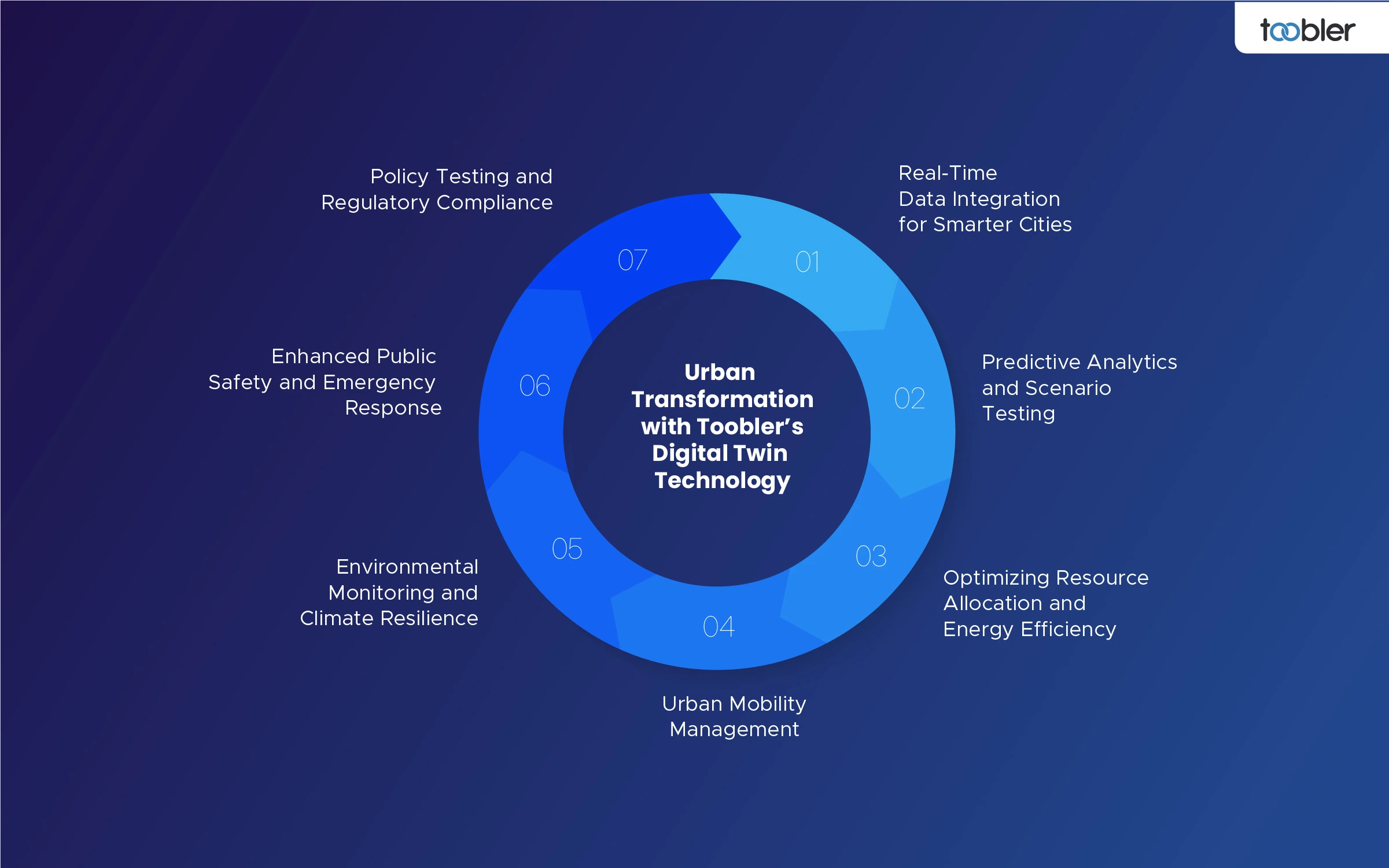
2. How Do Digital Twins Support Urban Planning?

Digital twins enable scenario testing for traffic, zoning, and disasters, optimizing resource allocation and stakeholder collaboration in projects like Virtual Singapore.

3. How Does a 3D Digital Twin Model Help City Planners?

3D digital twin models like Helsinki's visualize infrastructure changes, simulate pedestrian flows, and integrate green initiatives for data-driven decisions.

4. What Data is Used to Create a Digital Twin?

Core data types range from satellite imagery, LiDAR scans, traffic sensors and building BIM files to weather APIs and citizen feedback used to create accurate, modified versions of cities.

5. How Do Digital Twins Improve Smart City Initiatives?

They make cities smarter by allowing predictive maintenance, energy efficient systems and citizen engagement (shown through UK NDTP for sustainable infrastructure).

6. How Accurate Are Digital Twins for Urban Planning?

Accuracy reaches 95%+ with high-res LiDAR and real-time IoT feeds, though it depends on data quality and update frequency for reliable simulations.

7. What is the future of digital twins in urban planning?

AI integration and edge computing will make twins hyper-realistic by 2030, scaling to entire regions for climate-resilient, autonomous urban ecosystems.